Europe 2010 - The Slovenska Planinska Pot (the Slovenian High Route)
23 Jun - 19 Jul 2010
All content copyright © Ashley Burke 2010. Not to be copied, duplicated or used for any purpose without permission.
Europe 2010 - The Slovenska Planinska Pot (the Slovenian High Route) 23 Jun - 19 Jul 2010
All content copyright © Ashley Burke 2010. Not to be copied, duplicated or used for any purpose without permission. |
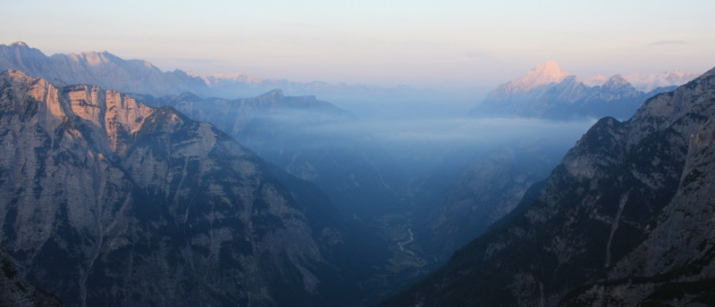
Early morning views down the Soča valley from Pogačnikov dom
Contents
Stage by Stage - Photos and Track Notes
Slovenia is a tiny country, only a third of the size of Tasmania. Much of the northern part of the country is mountainous, being the south-easterly end of the European Alps. Through the heart of the highest mountains of Slovenia passes the "Slovenska Planinska Pot", a long distance walking trail, or rather, a hiking route that links some of the many alpine trails into a continuous route from one end of the country to the other. Starting in Maribor, a city in the north east of the country, the route traverses westwards through the Kamniško-Savinjske Alps and then the Julian Alps before turning south and working its way to the coast, a total walking distance of around 500km.
Completing the walk from start to finish would be an undertaking of at least 6 weeks duration, and it was never the intention of the founders of this walk that it be completed from start to finish in one go. Indeed, different parts of the route are best done at different times of year, as in winter the mountains are impassable and in summer the lowland and coastal sections of the walk are too hot. So walking the route from beginning to end in a single season isn't recommended and is relatively rarely done. And as is normal throughout Europe, many hikers visit the mountains on day trips or weekend hikes, and the route is well suited to being done in short sections as there are many options for accessing different sections of the route.
Having said this, I am from Australia so given that Slovenia is a long way to go for a walk, I hiked the trail for 4 weeks in the summer of 2010, starting in Slovenj Gradec and ending in Bohinjska Bistrica. This section of the walk included all the high mountain stages, and fortunately we enjoyed stable weather for the entire duration of our trek.
I highly recommend the Cicerone Guide "Trekking in Slovenia" which describes the entire route in great detail. This guide book describes the route in 12 stages of around 3-4 days each, and I have organised this web page in stages consistent with those in the book. We completed stages 2 through to 8, and omitted stages 1 and 9-12. The Cicerone guide is particularly useful for people like me who do not speak the Slovene language and therefore this book was my primary source of information for all aspects of the route. The route can be navigated easily using the guide book in conjunction with the maps of the area.
The sections of the route that I did are covered by four 1:50000 maps. These maps are produced by the Planinska Zveza Slovenije (the Slovene Alpine Club) and can be purchased in the mountain huts en route. I bought my maps in a bookshop in Maribor. These are the maps needed for the sections of the route described on this web site:
| Pohorje | Needed only for the first day from Slovenj Gradec. |
| Kamniško-Savinjske Alpe | Used for the rest of Stage 2 and all of Stage 3 |
| Karavanke | Used for Stage 4 and most of Stage 5 |
| Triglavski Narodni Park | Used on the last day of Stage 5 and all of Stages 6, 7 and 8. |
As is the case throughout the European Alps, camping is not permitted except in designated camp grounds and in Slovenia these are few and far between, and located deep in the valleys rather than high in the mountains. The standard form of accommodation for the mountain walker in Slovenia and throughout western Europe is the mountain hut. In Slovenia these are called dom or koča. A dom is usually larger than a koča but apart from that there is no difference between the two. The huts are owned and run by the Planinska Zveza Slovenije (the Slovene Alpine Club) and if you are a member of this club, the cost of accommodation is half price. However, I was unable to work out how to join this club en route so was forced to pay full price for the accommodation throughout the trek. Fortunately Slovenia is generally cheaper than other parts of western Europe.
The mountain huts are very clean and comfortable with bedding provided so it is not necessary to carry a sleeping bag. However, we did carry sleeping bags and on a couple of occasions we were very thankful that we had. We did not pre-book our accommodation in these huts and this was usually not a problem although on one or two occasions we arrived at a hut to find it completely booked out and were forced to endure a mostly sleepless night lying on the dining room floor. And on one occasion we arrived at a hut to find it closed for renovations and were forced to find a place to bivvy outside. Fortunately the weather was fine.
All the mountain huts have restaurant style dining areas and in addition to these there are many farm houses, cafés and other localities en route that serve food and drink. Many of these are very popular destinations for local day trippers. So Slovenia, like the rest of the Alps, is geared towards restaurant style catering for pretty much all meals throughout the route. It would be possible to complete the entire route without carrying much food of your own or doing any self catering. In my case however, I have a personal preference for cooking my own food and additionally the cost of eating in hut restaurants for 4 weeks of continous trekking becomes very high unless some degree of self catering is undertaken. I therefore carried my own food and small gas stove on this trek. For the most part, staying in the huts and cooking your own food there is not a problem, provided you ask the hut warden for permission to do so. In by far the majority of cases the hut wardens were more than happy for us to use our own stove for cooking. Usually it would be prudent and polite to only cook and eat outside the hut. In one or two cases the hut warden asked us to use the stove only a certain distance away from the hut, but these cases were very rare.
Gaining access to supermarkets for restocking our packs with food was usually not a problem. At the end of each stage of the walk there was either a sizeable village or town with a shop, or else there was a road from where there was a regular bus service down to a nearby township. For example, when we arrived at the end of Stage 6 at the road pass of Vršič, we stayed overnight in Poštarski dom. Then in the morning we got the bus down to Kranjska Gora, bought food at the supermarket there, then got the bus back to Vršič by lunch time and then set off on Stage 7 that afternoon. Keeping our packs adequately stocked with food throughout the trek was never a problem.
The geology of the mountains of Slovenia is primarily limestone and therefore surface water is rare in the mountains. Running streams are only found in the deep valleys, and since much of the high route goes through the limestone mountains, water along the route is scarce. It is common to walk all day without finding any water. Even the mountain huts themselves rely on rainwater runoff from their roof for their water supply and it is common in summer for some huts to run out of rainwater. At such times bottled water is available to be purchased for drinking. I never once had to resort to buying bottled water and was always able to scrounge some rainwater from the hut or melt snow from a nearby snowdrift or obtain water one way or the other. But it was a close-run thing - it is no exaggeration even for an Australian who is used to hiking long distances without water to say that water along the Slovenian High Route is often hard to come by. There are occasional natural springs from which flow clear and pure mountain water and some of the huts take advantage of these by directing some of their flow into a water trough outside the hut.
One thing to note is that the Slovenians and European people generally will tell you that the rainwater from the hut roof or elsewhere is not fit for drinking. This is generally untrue, and whilst the water might have an odd smoky taste at some of the huts, it is always drinkable. Or at least, I'm still alive and well after having drunk nothing but rainwater for a month. Drink the water at your own risk of course.
The Slovenska Planinska Pot is a true "high route", as it never shies away from the high ground or from scaling the highest peaks and ridges available. Unlike other long distance trails in Europe, the Slovenska Planinska Pot keeps to the high ground rather than the valleys, and in the high mountain stages this means scaling precipitous peaks using fixed cables or via ferrate. The seven stages of the Slovenska Planinska Pot that we did vary considerably in the terrain, scenery and level of difficulty. Stage 2 is essentially a route through forested hills and rural country with no real difficulties. Only on the last day does the route emerge into a true alpine landscape, when it crosses the summit of Raduha at 2062m. Stages 3 and 6 are true mountain stages and are very challenging. These mountains would be completely impassible were it not for the steel cables, spikes and rungs (via ferrate) that assist an experienced trekker in scaling these mountains. Stage 7 is a wonderful extension to Stage 6, its primary objective being the beautiful summit of Jalovec. Stage 8 is also very mountainous but less so than stages 3, 6 and 7, and takes in the southern arc of the Julian Alps. Stages 4 and 5 are less mountainous than stages 3 and 6 but are nevertheless still alpine or sub-alpine, and include some beautiful walking near the Austrian border with tremendous views, wildflowers and many other attractions.
Stage by Stage - Photos and Track Notes
Below are links to photos and notes from each stage of the walk. These stages are those in the Cicerone Guide Trekking in Slovenia. As mentioned the whole Slovenska Planinska Pot is described in 12 stages, but we did only stages 2 - 8 on our visit in June-July 2010. Where we varied our route from that described in the Cicerone guide, this is noted.
| Stage 2 | 23 - 26 Jun 2010 | Bus from Maribor to Slovenj Gradec. Start Stage 2 of the walk from Slovenj Gradec to Solčava and Robanot Kot. |
| Stage 3 | 27 Jun - 2 Jul 2010 | From Robanov Kot through the Kamniško-Savinjske Alps to Zgornje Jezersko. |
| Stage 4 | 2 - 3 Jul 2010 | From Zgornje Jezersko (or Podlog) to Tržič and then the tiny hamlet of Srednja Vas. |
| 4 Jul 2010 | Rest day in Srednja Vas. Cycle to Bled and visit the lake. | |
| Stage 5 | 5 - 8 Jul 2010 | From Srednja Vas to Mojstrana and then up the Vrata valley to Aljažev dom. |
| Stage 6 | 8 - 11 Jul 2010 | From Aljažev dom into the Julian Alps. Triglav and the extremely challenging Jubilee route, then down to Vršič. |
| Stage 7 | 12 - 13 Jul 2010 | From Vršič to the summit of Jalovec and down to Trenta. |
| 14 Jul 2010 | Rest day in Trenta. Bus to Bovec to pick up supplies. | |
| Stage 8 | 15 - 19 Jul 2010 | From Trenta through the southern Julian Alps to Bohinjska Bistrica. |
| 20 Jul 2010 | Rest day in Bohinjska Bistrica. Cycling in the valley and around the lake. | |
| 21 Jul 2010 | Train back to Maribor. |
All content copyright © Ashley Burke 2010. Not to be copied, duplicated or used for any purpose without permission. Page created 25 Sep 2010, last updated 14 Oct 2010. |