The Three Peaks
The Classic Southern Blue Mountains Bushwalk
All content copyright © Ashley Burke 2008. Not to be copied, duplicated or used for any purpose without permission.
The Three Peaks The Classic Southern Blue Mountains Bushwalk
All content copyright © Ashley Burke 2008. Not to be copied, duplicated or used for any purpose without permission. |
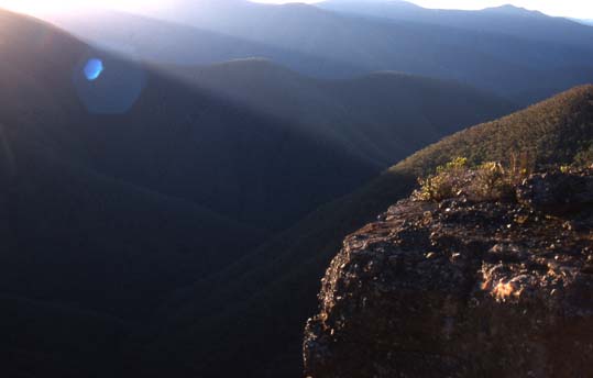
The Narrow Neck Plateau, part of the Three Peaks route
Contents
The Trail Runner's Guide to the Three Peaks
Aborting your Three Peaks Attempt
The Three Peaks Route in 2022 - Post Bushfires and Floods
Photos of the Summit Cairns and Logbooks
Historical and Memorable Three Peaks Epics
| IMPORTANT UPDATE FEB 2022: The 2019-2020 bushfires followed by 2 wet summers has resulted in the entire area of the Three Peaks being transformed beyond recognition. Much of the route is very overgrown and thick with dense regrowth. Progress is extremely slow and difficult between the Coxs River and Mt Cloudmaker. The Three Peaks, the Katoomba to Kanangra and other well known routes in this area are now very challenging and difficult. Please read the section The Three Peaks in 2022 - Post Busfires and Floods before heading out. YOU HAVE BEEN WARNED. |
The Three Peaks is one of the classic hard and very challenging walks of the Blue Mountains, with a history dating back to the early 1960s. Starting and ending in Katoomba, the walk is more than 90km long and involves over 4000m of vertical climbing and descending. The walk includes the summits of three major Blue Mountains peaks, Cloudmaker, Paralyser and Guouogang. A key challenge of this walk is to complete the entire walk within 48 hours. The trip is not considered the Three Peaks unless it is completed in under 48 hours. The route heads south from Katoomba along the Narrow Neck plateau, then through the Wild Dog Mountains and down to the Coxs River. It then ascends each of the Three Peaks in turn, descending into deep gorges between each peak before returning to the Coxs River and heading back through the Wild Dog Mountains, along the Narrow Neck and back to Katoomba. The route includes two major national parks, the Blue Mountains National Park and the Kanangra Boyd National Park.
The Three Peaks was traditionally a walk for hard core bushwalkers, and in recent times it has become increasingly popular among some trail runners, who have taken on the Three Peaks as an extension of their sport.
On this web page I describe this challenging walk in detail, provide some photos of the area and provide some useful information for people intending to undertake this 24-48 hour adventure.
The Three Peaks only counts as the Three Peaks if it is completed from start to finish in under 48 hours. Most bushwalkers attempting the Three Peaks usually carry some provisions for camping overnight and incorporate some sleeping or camping whilst en route. Provided you walk long and hard, it is possible to incorporate camping and sleeping into the trip and still complete the entire trip within the required 48 hour cutoff. Most trail runners on the other hand would aim to travel extremely light and will attempt the route with no plan to sleep or camp. Regardless of whether you are a bushwalker or a trail runner, and regardless of whether or not you plan to camp en route, some walking at night is inevitable. If you do plan to sleep or camp, these rests need to be timed carefully so as not to let too many hours slip away. A very fit and fast bushwalker carrying a light pack can complete the walk in under 48 hours with an allowance of around 12-15 hours for sleeping, cooking and resting. A fast trail runner with good off-track walking, hill climbing and navigation skills can expect to complete the trip in under 30 hours.
A special and relatively rarely accomplished achievement is to complete the Three Peaks in under 24 hours. In order to achieve this you have to power walk continuously for 24 hours with no sleep and only short and infrequent rests. You also need to run or jog some of the runnable sections such as the Narrow Neck fire trail and sections of the Wild Dog Mountains trail. Successful Three Peaks trips in under 24 hours are relatively rare.
Personally, if I choose to bushwalk the route with an overnight break of 10-12 hours, I typically complete the walk in around 40 hours. On two occasions I have completed the entire trip without stopping to sleep, and my fastest overall time out of these two trips was 25 hours and 33 minutes. This can only be achieved with the barest minimum of rest stops.
Typically I use the rule of thumb that at the pace that I am able to sustain, I need around 26 hours of time on legs to complete the trip. My actual Three Peaks time will be this amount plus however much time I spend resting or sleeping during the walk.
With this in mind, a key consideration is what time of day or night to start the walk, as your start time dictates what sections of the walk will be covered in daylight and what sections of the walk must be done at night. The central part of the walk on the far side of the Coxs River, which includes all three of the Three Peaks is the part of the trip where the terrain is roughest and trails faintest or non-existent and therefore the timing of your trip should be such that this section of the walk is done in daylight. This usually means starting out from Katoomba late on Friday night and walking the length of the Narrow Neck and beyond to Medlow Gap, Mobs Soak, Mt Yellow Dog and on to the Coxs River at night. The overall objective is to ensure that as much off-track walking as possible is done in daylight. The way you achieve this depends on your speed and whether or not you intend to camp en route. Here are some options, ranked according to speed:
| Option | Your Role | Intended Three Peaks Time | Description |
| 1 | Bushwalker | 44-48 hours | Start the walk at around 8-9pm and walk to Coxs River, catch 3 hours sleep, rise at first light. Climb Cloudmaker and Paralyser and hopefully Guouogang before dark, camp when daylight fades, usually on Guouogang or Bullagowar, then complete the trip the following day. |
| 2 | Bushwalker | 38-42 hours | Start the walk at around 11pm and walk to Coxs River. Don't stop here, it should be just getting light as you climb Mt Strongleg and it should be fully light by the time you reach the summit of Mt Strongleg, from where you need full daylight. Then continue to climb all the three peaks, stop on Guouogang or Bullagowar to camp as light fades. Rise at first light and complete the trip by about lunch time or early afternoon. |
| 3 | Bushwalker | 34-40 hours | Start the walk around sunrise or just before first light. Walk continuously, climbing Cloudmaker first. By the time you reach Paralyser it will be getting dark. Camp on the top of Paralyser near the logbook. At first light the following day continue the trip to Guouogang and finish in Katoomba before dark on the next day. |
| 4 | "Tiger walker" or trail runner | < 30 hours | Start the walk at around midnight and jog the Narrow Neck and all runnable sections of the route to the Coxs River. Keep going up Mt Strongleg and it should be starting to get light by the time you reach Mt Strongleg with enough daylight by now to navigate to Dex Creek and on to Cloudmaker. Keep going throughout the next day to complete all three peaks. By the time it is getting dark again you will hopefully be back on the Wild Dogs track from where it is walking track or fire trail all the way back to the finish. |
| 5 | "Tiger walker" or trail runner | < 30 hours | In this option you do the Three Peaks in reverse, climbing Guouogang first. This requires you to leave formed tracks earlier so you need to leave later so that you have daylight when you need it. Start at around 2am so that you are making your way up Guouogang as it is starting to get light. Climb all the three peaks during the day and by the time it is falling dark again you are either on the track descending from Mt Strongleg to the Coxs River or well on your way back to Katoomba on the Wild Dogs track. |
Below I show the timings of my various Three Peaks trips including the time of day or night that I reached each milestone. These timings can serve to help plan your trip, should you ever be crazy enough to want to do the Three Peaks in a similar number of hours that I have done.
The Three Peaks starts and ends in Katoomba although there is sometimes some disagreement or misunderstanding about where in Katoomba is the precise starting and ending point, and at what point the trip must be timed from. Here are some generally accepted boundaries about which there would be no disagreement.
The "official" Three Peaks starting point is the Water Board Ladders car park, otherwise known as the Climbers car park, situated on the Narrow Neck road about 1km closer to Katoomba than the Golden Stairs. It is at GR 489644 on the Katoomba 1:25000 topographic map (second edition), or GPS ref -33.729961, +150.287942. This is where the walk is timed from. Normal etiquette is to walk to this point from somewhere in Katoomba, although driving to this point and then starting from here is generally accepted.
Provided that you start from the correct starting point then you may choose any route, as long as you climb each of the Three Peaks (Cloudmaker, Paralyser and Guouogang) and sign the log book that is on top of each peak. Although you are free to choose what route you take, most people choose one of two main routes, or a minor variant of one of these routes. Most people climb Cloudmaker first, followed by Paralyser and then Guouogang although doing the route in reverse is possible. Below are the two main routes that people normally take on the Three Peaks.
I have highlighted the difference between each route in a different colour. Routes 1 and 2 are the same as far as the final peak Guouogang. It is the return journey from Guouogang to Katoomba that differs between these two routes.
Route 2 is longer than Route 1 but is more scenic and a more complete round trip with less repetition. Whereas on Route 1 you do the entire section from Mt Yellow Dog to Katoomba twice, on Route 2 only the section of the Narrow Neck Road north of the fire tower is done twice.
Early Three Peaks trips of the 1960s did not have the convenience of a track around the Wild Dog Mountains via Mobbs Soak so a different route was taken. These early trips were a variant of Route 2. From Medlow Gap they would walk down White Dog Ridge to the Coxs River and then follow the Gangerang Range to Dex Creek and on to Cloudmaker. Nowadays, Three Peaks trips done by this traditional 1960s route are relatively rare.
This website deliberately does not include detailed route maps, links to GPX files or any other information to specify what exact route you should take on your Three Peaks trip. This is partly because there is no set course in the first place, Three Peaks ethos is that you are free to choose your own route. There is also the safety concern around the fact that the Three Peaks is a remote wilderness area, and all who undertake the Three Peaks should be competent in navigation and able to find their own way to safety using a map and compass if something goes wrong. For these reasons I do not provide GPX files or detailed course maps on this site, so please do not ask me to provide this, I will politely decline! I offer training in map and compass navigation at very reasonable rates and you can find out more about my navigation courses on my Navigation Page. So please include the Kanangra and Jenolan 1:25000 topographic maps in your Three Peaks kit list, as well as a quality baseplate compass.
Remember also that the Three Peaks has a tradition dating back to the 1960s, and back then bushwalkers headed out with a compass and the old 2 inch to the mile topographic maps and found their own way. In keeping with this tradition, there is no reason why we shouldn't still do the same.
Upon the summit of each of the Three Peaks is a logbook and for your trip to count as the Three Peaks it is a requirement that you enter your name and the date and time in each of these three logbooks as proof that you were there. There have been instances of bushwalkers neglecting to do this to save time but it is widely felt in the bushwalking community that entering your name in each logbook is compulsory on Three Peaks trips. Of course, no one is obliged to do so, and anyone is entitled to do the route without signing the book, however it is considered an error to refer to such trips as "The Three Peaks". It is only a Three Peaks trip if you sign each logbook and return to the starting point within 48 hours. Any other trip is just a normal bushwalk.
The Three Peaks trip has a history and tradition going back to when bushwalkers in the 1960s undertook the challenge of doing the walk in under 48 hours with minimal gear and fanfare. It has always been a personal challenge and never a race. These days the route has attracted modern adventure runners and wild claims have been made by people stating that they have completed the walk in something like 13 hours. Funnily enough, the people making such claims also mention that they don't bother signing the logbooks on each peak and hence these claims cannot be verified. In the interest of maintaining the integrity of the Three Peaks walk in keeping with its traditions, there are some basic parameters which most traditional Three Peaks walkers would agree are etiquette that should be adhered to for a trip to count as a legitimate Three Peaks trip. These are:
The reason for doing the Three Peaks in the order of Cloudmaker then Paralyser then Guouogang is largely historical. Remember that in the 1960s when the Three Peaks was first undertaken, there was no track around the Wild Dog Mountains and a route down White Dog Ridge and the Gangerang Range was taken. Since then, the habit of doing the Three Peaks in the order described on this website has stuck.
It is quite possible to do the Three Peaks in reverse (climbing Guouogang first, then Paralyser and Cloudmaker) and this option appears to have come into be favour among some fast trail runners. To get to Guouogang first means leaving formed trails sooner than you would if doing Cloudmaker first. Therefore you would set out from Katoomba later in the night when doing the trip in reverse than you would when doing it conventionally. This is a disadvantage unless you expect to complete the trip in around 24 hours, because you are likely to already be sleep deprived from the outset. It is especially difficult to do Route 2 in reverse, as you would require daylight from the Narrow Neck fire tower onwards, which is less than 2 hours from the start.
For these reasons, doing the Three Peaks in reverse seems to be an option favoured only by some of the very fastest trail runners or "tiger walkers", as the fastest bushwalkers came to be known.
The Trail Runner's Guide to the Three Peaks
The sport of trail running has enjoyed a spectacular increase in popularity recently and organised ultra marathon events in the Blue Mountains such as The UTA100 (formerly North Face 100) attract many hundreds of runners every year. Some ultra runners with a keen eye for seeking new challenges at the extreme off-trail end of their sport have shown interest in the Three Peaks. I absolutely welcome this and indeed, I have taken up trail running myself with much enthusiasm in the last couple of years. I am therefore providing this "Trail Runner's Guide to the Three Peaks" section to provide my fellow runners some information from the perspective of a runner rather than a bushwalker.
I say this many times on this web page but it is worth saying it again. Trail runners should be under no illusions about what they are letting themselves in for when undertaking the Three Peaks. The Three Peaks is unlike trail running in many ways and one of these is the lack trails for much of the route. Walking off trail is very different from walking or running on trail. Even the roughest trail on the toughest trail runs has been pounded into submission by the passage of many feet. By contrast, off track walking is on ground which hasn't been tamed or subdued by pathways. Loose rocks are everywhere, steep and uneven ground is the norm, scrub and sticks and logs are in the way everywhere and you simply can't run through this country. You must be careful not to sprain your ankle, trip over, fall or sustain other injury. Almost all the course beyond the Coxs River is off trail or not runnable. Even though the Three Peaks is well under100km in distance only elite athletes are able to complete the trip in under 20 hours. A few years ago Ben Artup managed an extraordinarily fast time of around 19 hours. This says something about the difficulty of the Three Peaks. My personal experience is that the Three Peaks is harder than any trail run I have ever done.
Furthermore, it is likely that you need to carry more gear and food than on most trail runs.
Trail runners should be under no illusions about what the Three Peaks entails. In fact, the Three Peaks is not a trail run. Well for a start, most of the route has no trail. And for seconds, much of the route is not runnable. That's why the Three Peaks is called a bushwalk. Bush+Walk. It is also why the Three Peaks is not called a trail run. Trail+Run. Well, sections of the Three Peaks can be run. In fact, the entire Narrow Neck and beyond as far as Medlow Gap overlaps with the UTA100 (formerly North Face 100) route. And much of the Wild Dog Track down to the Coxs River can be run. Beyond that there is little opportunity for running. It's either too steep or there is no track and the terrain is too rough for running. Some (but certainly not all) of the track from the Coxs River to Cloudmaker can be run, and there is some limited opportunity for running downhill on some sections. One downhill section that is certainly NOT runnable is the route off Paralyser to the base of Nooroo Ridge! This is steep, loose and rocky and must be taken with care. Trail runners must be aware that there are no first aid officers at call and no aid stations. Please take care, and don't be ashamed to walk!
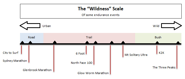
To give you an idea of where The Three Peaks sits on a scale of "tracklessness" or "wildness" compared to other well known trail runs, check out this "Wildness" scale:
Unlike trail running where official race records for each event are well documented, no official data is kept for The Three Peaks. The Three Peaks records appear to be the following. Please contact me if you know have details on any Three Peaks records and evidence, dates, times etc.
| Fastest Male | Matthew Scholes and Loughlinn Kennedy in 17 hours 14 minutes on 28 July 2018. |
| Fastest Female | Emma Murray in 23 hours 40 minutes solo. |
| Oldest under 48 hours | David Trinder from Sydney Bushwalkers who completed the 3 Peaks in just under 48 hours a few weeks before his 70th birthday! |
Please note that claims by Peter Treseder of 3 peaks times of around 13 hours have been debunked and discredited and are not recognised.
Below is a record of some known sub-24 hour 3 Peaks trips. I hope to add to this as more sub-24 hour 3 peaks trips come to light.
| Party | Date | Three Peaks Time | Notes | Trip Report |
Matthew Scholes Loughlinn Kennedy |
28 July 2018 | 17 hours 14 minutes | Two modest and humble trail running legends smashed the longstanding record on 28 July 2018. Not the sort to write a trip report, Loughlinn simply writes "I believe we may have set a pretty fast time", which has to be the record for Three Peaks understatements. Loughlinn continues, "The challenge requires careful planning, good confident navigation and brute endurance, as every stick, rock and plant in the Kanangra wilderness has evolved for survival. Bottom line is it’s a harsh but beautiful place". The trip was done in reverse (Guouogang-Paralyser-Cloudmaker). |
None |
Warwick Daniels John Fantini |
1966 | 18 hours 22 minutes | This legendary and almost mythical Three Peaks time was set way back in 1966 by then "Tiger Walkers" Warwick Daniels and John Fantini. The record stood for 52 years until broken by Matthew Scholes and Loughlinn Kennedy on 28 July 2018. | |
| Ben Artup | 18 Sep 2010 | 19 hours 5 minutes | A very fast time, timed from the Golden Stairs. Started trip with Branden Haywood who did not complete the Three Peaks. Done in reverse (Guouogang-Paralyser-Cloudmaker). | |
Alex Debono Andrew Mitchell William Landers Richard Wood |
12 Apr 2003 | 20 hours 4 minutes (Alex Debono) 21 hours 43 minutes (William Landers and Richard Wood) 24 hours 30 minutes (Andrew Mitchell) |
An extraordinarily fast time by Alex Debono and an epic case of hypoglycaemia on the part of Andrew Mitchell who still managed 24 hours and 30 minutes despite that. A great report on this epic by Richard Wood. | |
| Alastair McDowell | 14 Apr 2018 | 20 hours 56 minutes | One of the fastest recent Three Peaks trips. Oddly enough, exactly the same time as Glenn Horrocks in 2017. | |
| Glenn Horrocks | 22 Nov 2017 | 20 hours 56 minutes | https://www.strava.com/activities/1286710692/overview | |
Athol Abrahams Dave Dash |
7 May 1966 | Approx 21 hours | A true classic trip done in 21 hours with tins of pineapple, chocolate and licorice allsorts, coupled with doing the Three Peaks in reverse (Guouogang-Paralyser-Cloudmaker) and returning via Gentles Pass and White Dog Ridge. One of the true classics. | |
| Nikolay Nikolaev | 20 July 2019 | 22 hours 15 minutes | https://www.facebook.com/nikolay.nikolaev.526/posts/10216699852621717 |
I am interested in compiling a more comprehensive record of Three Peaks records and past Three Peaks trips. There have been some epic trips, some extraordinarily fast times, many just scraping through in the 48, and a countless number of colourful capitulations. If you would like to share your Three Peaks experiences, please email me.
Please note: If you want your Three Peaks trip to be recognised as such, then please adhere to Three Peaks Etiquette. Do the trip unsupported, without aid, sign the logbooks and do not mark the route in any way whatsoever. Leave the bush in at least as wild a state as that in which you find it.
Event Schedule for the Trail Runner
Ok well the Three Peaks isn't an "event" like other trail running events with race directors, starting guns, aid stations, bibs, timing mats and all the rest of it. It's just a group of people heading out into the bush. But in keeping with what trail runners are used to in planning for a race, here would be a typical schedule for a good trail runner aiming for a sleepless Three Peaks and a time of under 30 hours. Obviously the timings below are a general guide only, assuming an overall time of around 25-27 hours.
| Time | Event |
| 22:00 Friday | Park car in suburban Katoomba and walk or jog to start. |
| 22:30 Friday | Official start at the climbers car park on Glenraphael Drive. |
| 01:30 Saturday | Possible water stop or brief rest at Mobbs Soak. |
| 04:30 Saturday | Arrive Coxs River. Take shoes off for crossing of river. Start climb of Strongleg Ridge. |
| 07:00 Saturday | Reach Cloudmaker, the first of the Three Peaks. Brief rest. |
| 09:00 Saturday | Cross Kanangra Creek. Brief rest. Collect water and start climb of Paralyser. |
| 10:45 Saturday | Reach summit of Paralyser. Brief rest, possibly the longest rest of the trip. |
| 12:30 Saturday | Cross Whalania Creek. Brief rest. Collect water and start climb of Guouogang. |
| 15:00 Saturday | Reach summit of Guouogang. A well earned rest. |
| 17:30 Saturday | Cross Coxs River. Brief rest. Collect water and start climb of Yellow Dog Ridge. |
| 21:30 Saturday | Reach Medlow Gap. |
| Midnight Saturday/Sunday | Reach the official finish! Yay!! |
| 01:00 Sunday | Back at car. It is the dead of night in Katoomba. Drive to somewhere cosy and warm for a well earned shower and sleep followed by a hearty breakfast! |
Unlike trail runs, where runners must keep to a clearly defined course, The Three Peaks has no defined course except that the starting point and finish point are defined (see Starting and Ending Point) and you must climb each of the Three Peaks and sign the logbooks.
Much of the route is not marked and nor should it be. Unlike most trail runs, there are no ribbons tied to trees, no arrows, no tape - nothing. Much of the route is wilderness and should be respected as such. Anyone attempting the Three Peaks needs to be competent in navigation and able to find their own way through untracked country. Do not spoil the wilderness nature of the trip by marking the route in any way whatsoever.
Please also see the Navigation section of this web page for an explanation of why I do not provide GPX files or detailed course maps on this website.
There are no aid stations and no possibility of resupplying yourself with anything other than water on the route. Leaving a cache of food for you to pick up along the way is grounds for disqualification. If you get yourself into the Three Peaks you need to get yourself out of it again, either by completing the trip or by aborting the trip by one of the escape routes mentioned below.
I'm not a race director and there is no one to set the rules when doing the Three Peaks but this wouldn't be much of a trail running web page without a mandatory gear list!!! So check out my Three Peaks food list and gear list.
Other Bushwalking Challenges for the Trail Runner
Are you one of those people who are always looking for some new trail run or hard core ultramarathon course to add to your repertoire? And the Three Peaks isn't enough to quell your appetite? Well here are a few more classic Southern Blue Mountains bushwalks that might pique your interest.
In the interest of providing a consistent course length and direction for trail runners to compare and validate times and so on, I have nominated specific start and end points for the K2K and the K2K2K, and direction of travel, though of course anyone is free to do these trips in whatever direction and with whatever start and end points they like. If you would like to run these courses fast and to go onto the leaderboard, then I suggest you run the course with the start and end points as shown here.
| Acronym | Name | Description | Start Point | End Point | Distance | Time Required (Fast) | Time Required (Normal) | Leaderboard | |
| The 5 logbooks | The Three Peaks, but also include side trips out to Splendour Rock and Knights Deck to sign the logbooks there. This makes 5 logbooks in total for the trip, including Cloudmaker, Paralyzer and Guouogang. This would add at least 2 hours to the standard Three Peaks. | Same as for the Three Peaks. See here. | Same as for the Three Peaks. See here. | ~98km | 24 hours | 48 hours | |||
| K2K | Kanangra To Katoomba | Kanangra Walls - Gangerang Range - Mt Cloudmaker - Dex Creek - Mt Strongleg - Coxs River - Mt Yellow Dog - Medlow Gap - Narrow Neck - Katoomba Station | The barrier at Kanangra Walls car park. | Top of Katoomba street, at entrance to Katoomba station. | 54km | 12 hours | 24 hours | K2K Leaderboard | |
| K2K2K | (K2)² |
Katoomba to Kanangra Return | Just like a K2K only you start in Katoomba, walk to Kanangra and then turn around and walk back to Katoomba rather than bother with the huge car shuffle needed for the one way trip. Starting and ending at the same point as for the Three Peaks, you must walk to Kanangra, touch the barrier at the Kanangra Walls car park, then return. | Same as for the Three Peaks. See here. | Same as for the Three Peaks. See here. | 104km | 24 hours | 48 hours | K2K2K Leaderboard |
| K2K2K2K | (K2)³ |
Katoomba Kanangra Kowmung Katoomba | Start at Katoomba and walk the K2K to Kanangra Walls, then follow Gingra Range to the Kowmung, follow the Kowmung downstream to Ti Willa Creek, then cross over the lower Gangerang Range to reach the Coxs River, then Splendour Rock, then back to Katoomba. A truly classic trip, further and arguably harder than the Three Peaks. One of the great Blue Mountains walks encompassing an enormous swathe of the southern Blue Mountains. | 40 hours | 48 hours+ |
In hot and dry weather keeping properly hydrated can become one of the many challenges to deal with on your Three Peaks trip. There are long distances to walk between each water source and you need to balance the need to keep hydrated on the one hand with the need to avoid carrying large amounts of water on the other. There are only four points along the walk where water can be obtained with absolute certainty without making deviations from the route. These water points are:
In addition to the abovementioned water points there is Dex Creek, crossed on the approach to Cloudmaker, which normally contains a few pools of good water although in periods of prolonged drought this creek can sometimes be completely dry. Another water source is Mobbs Soak between Medlow Gap and Mt Yellow Dog but this can often be dry at the point where the track crosses it.
Given the very strenuous nature of the walk and the long hours on the move, combined with the need to keep the weight you're carrying at a minimum, it is particularly important to carry an appropriate amount of water with you - not too much and not too little. I normally adopt the rule of filling a one litre water bottle at each of the four water points mentioned above, except if I intend to camp before reaching the next water point, in which case I take two litres. At each water point I drink substantially before continuing on. I would say that carrying this amount of water would be the minimum needed to avoid dehydration, especially if doing the trip in hot weather.
An added complication is that some people consider the water in the Coxs River to be unfit for drinking without treatment. I never treat the water that I draw from the Coxs River and am happy to drink it straight but that doesn't mean everyone can or should. Just be aware that some people have been known to have had stomach upsets after drinking water from the Coxs River.
Food is a personal matter and everyone will have their own opinions and preferences regarding what food is best to take on a Three Peaks attempt. It also depends a lot on whether you are intending to do it as a bushwalk in 40-48 hours, or as a trail run in 24-30 hours. Those bushwalking and sleeping during the Three Peaks would be well advised to take a billy and matches and cook themselves one hot meal on the trip. A trail runner aiming for a sub 30 hour Three Peaks may choose to do the trip on high energy foods without stopping to cook. One thing is certain though, and that is that no matter how fast you plan on doing your Three Peaks, you must take enough calories with you to sustain you for at least 40 hours on the move. To set out on the Three Peaks without enough calories to last 40 hours is foolish, even if you're a sub 30 hour 3 peaker! Always allow enough food for emergencies and unforeseen delays.
For a list of food suggestions check my Three Peaks Food List. You must be totally self sufficient, and for your Three Peaks trip to be recognised you should not leave caches of food on the route in advance, nor should you have a support crew supplying you on the way.
You need to bring everything you need for total self sufficiency for up to 48 hours in the southern Blue Mountains wilderness. At the same time you must keep weight to an absolute minimum. I have compiled a kit list to help you prepare. This kit list has similarities to what would be compulsory gear on trail run events like the North Face 100 or Bogon to Hotham, but with some notable differences. Check out my Three Peaks Gear List.
Aborting Your Three Peaks Attempt
The history of Three Peaks trips is littered with the carnage of failed Three Peaks attempts so no treatise on this walk is complete without mention of the various ways of cutting it short or aborting the trip altogether. Perhaps the most common method of abandoning a Three Peaks trip is not to start it in the first place, and it seems that the number of people who say they are going to do the Three Peaks always far exceeds the number that ever actually end up doing it. Saying you're going to do it and actually doing it are two different things.
There may be many reasons for needing to abort your Three Peaks trip. Exhaustion, sleep deprivation, injury, knee pain, feeling sick, getting blisters, heat exhaustion or simply a dissipation of will to press on can lead the Three Peaks aspirant to decide to exit the trip early or cut it short. As it happens, there are many opportunities along the route for bailing out. At the summit of each of the Three Peaks the walker is confronted with two options:
Option 1: Continue along the Three Peaks route which involves doing a withering knee crushing descent all the way back to river level losing all the altitude you have just toiled hours to achieve and then face the prospect of climbing all the way up the other side in order to get to the next peak or back to Katoomba
or
Option 2: Abort the Three Peaks by taking the relatively easy exit route that exists from the top of each peak.
I will now describe the various options for aborting a Three Peaks attempt once started. These options might be described as the Three Peaks pikers handbook.
| Piking before Cloudmaker | If you need to pike before reaching the first peak Cloudmaker, then most likely your best option for aborting the trip is to retrace your steps back to Katoomba. |
| Piking at Cloudmaker | The summit of Cloudmaker is one of the most tempting points on the whole route for abandon your Three Peaks attempt. It is a long trek from Katoomba to here and two out of the three peaks still lie ahead of you. From the summit of Cloudmaker you can continue south along the Gangerang Range following the track to Kanangra Walls, a walk of about 4 hours. At Kanangra Walls it should be possible to flag a lift back to civilization from the car park. Another option from Cloudmaker is to follow Marooba Karoo Ridge north past Marooba Karoo Hill and onwards down to Kanangra Creek. Then follow Kanangra Creek downstream until you reach the Coxs River and then take the track up Yellow Pup Ridge and back to Katoomba. |
| Piking at Paralyser | With two out of the three peaks in the bag, piking at Paralyser is less common but it has still been done. From the summit you can continue along the ridge over Mt Cyclops and beyond to Thurat Ridge and Mount Thurat, from where you can pick up a fire trail leading out to the Jenolan Caves Road. Once on the Jenolan Caves Road you can flag a lift back to civilization. Another option is to descend from Paralyser to the junction of Kanangra Creek and Whalania Creek. You can then bypass Guouogang by following Kanangra Creek downstream until you reach the Coxs River and then take the track up Yellow Pup Ridge and back to Katoomba. |
| Piking at Guouogang | It is unusual to reach the summit of the third and last of the Three Peaks only to then abandon your Three Peaks attempt by taking the exit route that I am about to describe. But it can be done if injury or fatigue make it unwise to continue. It is quite easy from the summit of Guouogang to follow the Krungle Bungle Range south-west past Mt Krungle Bungle until you reach fire trails that eventually lead out to the Jenolan Caves Road. Another option from Guouogang is just to proceed back to Katoomba as you would to complete the Three Peaks trip only slacken your pace and resign yourself to completing the trip in more than the requisite 48 hours. |
The Three Peaks Route in 2022 - Post Bushfires and Floods
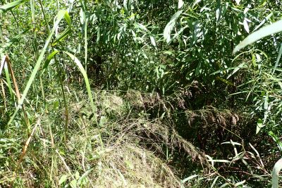
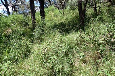
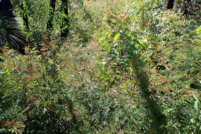
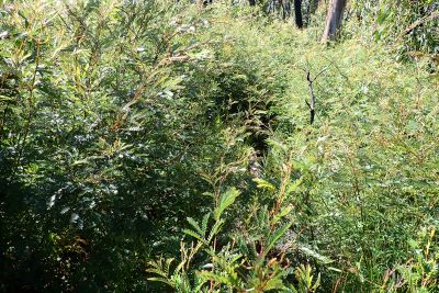
In the summer of 2019-2020 the entire southern Blue Mountains was severely burnt in bushfires. Most of the area covered by The Three Peaks, the K2K and other routes described on this page had not previously been burnt in the past 50 years. Following the bushfires were heavy flooding rains and two wet summers. The impact of this sequence of events has been extraordinary. Much of the area has been altered beyond recognition in terms of the vegetation encountered on the route. Where once you would have walked in open forested bush or on rocky quartzite ridges, this previously open ground is now choked with regrowth. Weeds, vines and dense wattle thickets are more than head high, and these thickets seem to go on endlessly in country that was previously relatively open.
Walking the route up Strongleg Ridge to Dex Creek and Mt Cloudmaker is now extremely slow, arduous and tiring, with dense regrowth almost the whole way.
Previously the route between Mobbs Swamp and Mt Yellow Dog would have been walked at night. In 2022 this would be a ridiculous proposition, the track is almost indiscernable even in the daytime, and you have to slowly pick your way through the dense thickets.
I have not personally completed all of the Three Peaks route since the bushfires, however I have climbed Mt Strongleg and beyond there from the Coxs River in February 2022. The route is extremely difficult and slow.
It is now virtually impossible to even consider attempting a 48 hour Three Peaks attempt. It would now require at least 4 days of arduous, tiring, frustrating, slow and difficult pushing through dense thickets and weeds.
YOU HAVE BEEN WARNED. DO NOT ATTEMPT THE THREE PEAKS WITHOUT A GOOD UNDERSTANDING OF THE CURRENT CONDITIONS.
Lower section of Strongleg Ridge, Feb 2022 |
Weeds on lower section of Strongleg Ridge, Feb 2022 |
Higher up, past Mt Strongleg, Feb 2022 |
Endless thickets of wattle past Mt Strongleg, Feb 2022 |
|---|
Once again, you have been warned.
My Three Peaks Trip Logs and Times
My first successful attempt at the Three Peaks was in 1988 and since then I have done the trip 16 times. From 2001 to 2008 I did the three peaks every year. The table below catalogues each successful Three Peaks trip that I have undertaken, with timings that indicate when I started out, what time I reached each peak and when I returned.
| Date | Route |
Start time | Rest at Coxs River | Cloudmaker | Paralyzer | Guouogang | Rest on 2nd night | Finish time | Total Three Peaks time | Remarks | Trip Report | |
1 |
Sometime in 1988 | Around 9pm | Around 3 hours | Not recorded | Not recorded | Not recorded | Around 12 hours on Guouogang | Around 4:45pm | 43 hours 50 minutes | Solo | ||
2 |
30 Dec 1989 - 1 Jan 1990 | Around 8pm | Around 3 hours | Not recorded | Not recorded | Not recorded | Around 12 hours on Guouogang | Around 7:30pm | Around 47 hours 30 minutes | With Anja | ||
3 |
24-25 Oct 1992 | 19:50 | Around 2.5 hours | 07:50 | 11:10 | 15:35 | 10 hours on Coxs River | 10:26 | 38 hours 30 minutes | With Rob Hynes | ||
4 |
26-27 Sep 1998 | 20:30 | Around 2.5 hours | 08:30 | 12:15 | 16:50 | Around 12 hours on Guouogang | 14:30 | 42 hours | Solo | ||
5 |
9-10 Oct 1999 | 20:30 | 3 hours | 08:15 | 11:45 | 16:45 | 11.5 hours on Bullagowar | 13:45 | 41 hours 15 minutes | With Rob Hynes | ||
6 |
14-15 Oct 2000 | 20:22 | 3 hours 45 min | 08:25 | 12:05 | 16:40 | Around 12 hours, past Bullagowar | 12:45 | 40 hours 30 minutes | Solo | ||
7 |
3-4 Nov 2001 | 20:00 | 3 hours 20 min | 08:25 | 12:20 | 17:05 | Around 11 hours, on Krungle Bungle Range | 13:00 | 41 hours | With Scott M and Alex M | ||
8 |
19-20 Oct 2002 | 19:15 | Around 3 hours | 07:25 | 11:20 | 16:00 | Around 11 hours, past Bullagowar | 12:30 | 41 hours 15 minutes | With Andrew Mitchell | ||
9
|
1-2 Nov 2003 | 21:00 | 3 hours 30 min | 08:20 | 11:50 | 16:30 | 10.5 hours, past Bullaowar | 12:05 | 39 hours 5 minutes | Solo. | ||
10 |
11-12 Sep 2004 | 23:30 | None | 08:00 | 11:50 | 16:50 | Around 10 hours, past Bullagwar | 12:15 | 36 hours 45 minutes | With Jo and Rob. Climbed Guouogang via Bullagowar | ||
11 |
19-20 Nov 2005 | 22:50 | None | 08:10 | 12:00 | 17:05 | Around 10 hours, past Bullagowar | 12:30 | 37 hours 35 min | With James Bevan | ||
12 |
28-29 Oct 2006 | 22:40 | None | 07:35 | 11:10 | 15:55 | None! | 02:50 | 28 hours 15 min | With Jo | ||
13 |
27-28 Oct 2007 | 22:50 | None | 07:55 | 11:50 | 16:40 | 10 hours, on Krungle Bungle Range | 12:40 | 37 hours 50 min | Solo | ||
| 14 | 15-16 Nov 2008 | 07:40 | None | 16:10 | 20:00 | 08:55 | 9 hours, on Paralyser | 18:18 | 34 hours 40 min | Solo | ||
| 15 | 1-2 Dec 2012 | 22:35 | None | 08:15 | 12:30 | 19:50 | 8 hours, on Guouogang | 16:30 | 41 hours 55 min | With Iza | ||
| 16 | 17-18 Oct 2015 | 22:40 | None | 06:55 | 10:25 | 14:45 | None! | 00:13 | 25 hours 33 min | With Susan |
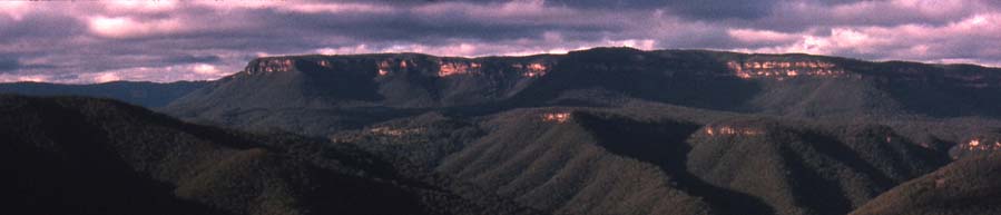
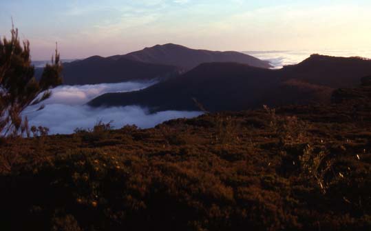
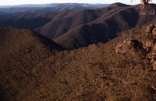
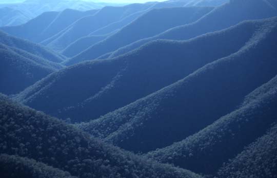
The below photos are of the general area of the Three Peaks taken on trips other than the Three Peaks. These photos will give an idea of the landscape and terrain of the Three Peaks route.
All these photos were taken well before the 2019-2020 bushfires which have altered the landscape dramatically. See the section The Three Peaks in 2022 - Post Bushfires and Floods.
 |
|
 |
On the far horizon can be seen the Narrow Neck plateau, which must be walked along at the start and finish of the trip. In the middle distance can be seen Strongleg Ridge with the sun on it, rising gradually with an undulating profile. This is the ridge that you climb to get from the Coxs River to the summit of Cloudmaker which is not in the photo but lies to the right of it. In the foreground is Marooba Karoo Ridge. |
 |
|
 |
A gorge of similar depth and size of this lies between Paralyser and Guouogang as well and this gorge too must be climbed into and out of on the Three Peaks. The Coxs gorge is similar too, and this must be crossed twice. |
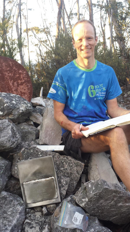
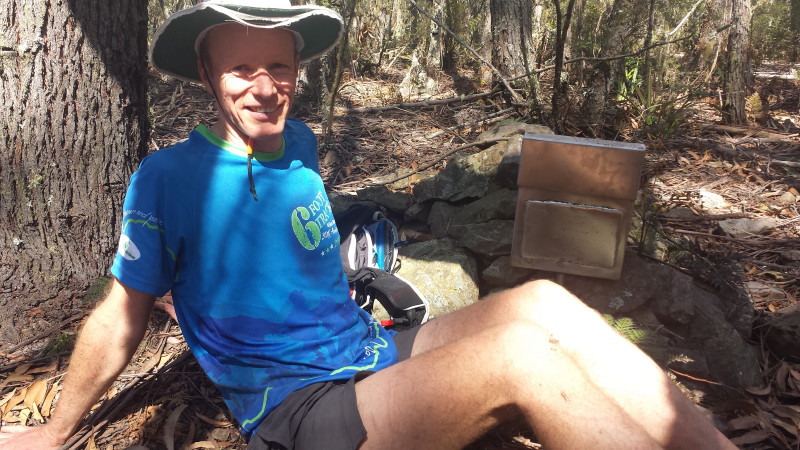
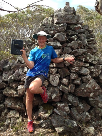
Photos of the Summit Cairns and Logbooks
Here are some photos of the actual summit cairns and logbooks taken from each of the Three Peaks. These photos were taken on Three Peaks trip in October 2015.
Historic and Memorable Three Peaks Epics
As mentioned, The Three Peaks has a history going back to the 1960s. No treatise on the Three Peaks would be complete without referencing some of the classic Three Peaks trips of the past. We have to respect the hard core walkers of the 1960s who did the Three Peaks with food and gear that would horrify the modern trail runner who are more at home with their Endurolyte, gels, power bars and lycra running outfit than the canvas packs and tins of pineapple and meat carried in the 1960s..
| Trip | Synopsis | Trip Report |
| Three Peaks in under 24 hours - Athol Abrahams and Dave Dash on 7 May 1966 | A true classic trip done in 21 hours with tins of pineapple, chocolate and licorice allsorts, coupled with doing the Three Peaks in reverse (Guouogang-Paralyser-Cloudmaker) and returning via Gentles Pass and White Dog Ridge. One of the true classics. | |
| Another Three Peaks trip in May 1966 with Graham Wootton and Jim Box | Graham writes of another historic 1966 trip via White Dog Ridge and the lower Gangerangs, then Gaspers Spur and Carlons Head. | |
| Michael Smith and Michael Dillon in September 1967 | This trip report again shows that White Dog Ridge and the Gangerang Range and Gentles Pass was the normal route back then. This is much further in distance than the two routes described on this web page. | |
May 1962:
Margaret (Meg) McKone (née Hailstone) Frank McKone Ray Jerrems Dave Philp |
Meg McKone (née Hailstone), aged 18 in May 1962 was the first female to complete the Three Peaks. She was one of a group of 4 from CMW. They took White Dog Ridge to the Coxs River, found the water level quite high and headed upstream. They had to partly swim across the river, and then headed up Moko Ridge and the Gangerang Range to Cloudmaker. They continued to Paralyser and Guouogang, camping at the base of Nooroo Ridge. Then on the final day they ascended Guouogang and returned to Katoomba via the Krungle Bungle Range, Gaspers Spur and Carlons Head. They completed the trip in just under 48 hours. Like the other 1960s trips this was a variation on what was then the normal route via White Dog Ridge and Gangerang Range. This variation via Moko Ridge was a longer and harder route than all present routes and was the earliest Three Peaks trip I have learned of to date. |
Also in 1966 was the first all female Three Peaks attempt. The trip included Flora Turton, Wendy Butler and Rae Barker (Sheridan). It is known that at least some of the party pulled out at Cloudmaker however I do not yet know whether any of the party completed the full Three Peaks circuit in under 48 hours.
More recently, in about 2004, three women from SUBW, Stacey Ly, Jo Boyd and Sarah Truscott completed the Three Peaks together and this trip became known as the "Three Chicks on Three Peaks" trip.
Some of the Three Peaks trips that I have been on have been written up. Here are links to trip reports for each Three Peaks trip where a trip report was written.
Three Peaks Trip Report, 3-4 Nov 2001
Three Peaks Trip Report, 19-20 Oct 2002
Three Peaks Trip Report, 1-2 Nov 2003
Three Peaks Trip Report, 11-12 Sep 2004
Three Peaks Trip Report, 19-20 Nov 2005
Three Peaks Trip Report, 28-29 Oct 2006
Three Peaks Trip Report, 27-28 Oct 2007
Three Peaks Trip Report, 15-16 Nov 2008
Three Peaks Trip Report, 1-2 Dec 2012
Three Peaks Trip Report, 17-18 Oct 2015
You are visitor number to this web page since 25 Feb 2014.
Web page created 11 Nov 2008, last updated 18 Feb 2022. All content copyright © Ashley Burke 2015. Not to be copied, duplicated or used for any purpose without permission. |